Our project has clearly shown that ideas and interpretations are not born instantaneously, but emerge through new observations and interdisciplinary discussions. These exchanges, encouraged by the Mines Paris – PSL approach, help to push back the boundaries of our knowledge.
Médard Thiry, researcher at the Geosciences Center
A multidisciplinary international collaboration enhancing cultural heritage
Since 2018, the international collaboration between Mines Paris – PSL and the University of Adelaide has combined their respective expertise in weathering geology and geomorphology to study the transformations of rocks over geological and prehistoric times. Together, they combined their geological approaches with archaeology to detail decimetric morphologies – that is, visible shapes and structures measuring between a few centimetres and ten decimetres (i.e. up to around one metre) – present on the walls of shelters and boulders to decipher traces of human intervention.
During this collaboration, Médard Thiry and Anthony Milnes examined the walls of a shelter in the sandstone of the famous Fontainebleau forest massif, south of Paris. This shelter, known since 1981 to contain the engraving of two horses in a late Paleolithic style, comparable to that of the Lascaux cave, on either side of a female pubic figure, turned out to present a miniature representation of the surrounding landscape.
Overall view of the female panel. The engravings of two horses on either side of the triangle are very fine and only visible on close-up, artificially lit views. Photo Médard Thiry.
This shelter 60 km south of Paris is remarkable in several respects. It is one of only three Paleolithic shelters identified in the Fontainebleau sandstone. These shelters are also the most northerly Palaeolithic ornamental sites currently known in Europe. Dating from the end of the last ice age, this environment is characterized by frozen ground for much of the year. Upper Paleolithic hunter-gatherers set up large encampments along the banks of the Seine, strategically positioned on the migratory routes of the big game essential to their subsistence.
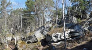
Chaos of sandstone blocks in the Fontainebleau forest massif, similar to those containing the engraved shelters. Photo by Médard Thiry.
Paleolithic art and engineering
Through his extensive research into the origins of Fontainebleau sandstone, Médard Thiry has recognized several small-scale morphological features of sandstone that cannot be explained by natural processes. These observations suggest that early humans modified the sandstone’s surfaces.
During an initial visit to the site in 2017, Médard Thiry established that Paleolithic humans had “worked” the sandstone, whose shapes evoked feminine figuration. They had accentuated natural slits that evoked a pubis and hip folds, and opened fractures allowing water to seep in and form a flow through the vulval slit, forming a controlled trickle. This hydrological device, activated after three days of water supply, is the first known evidence of water management by Paleolithic peoples.
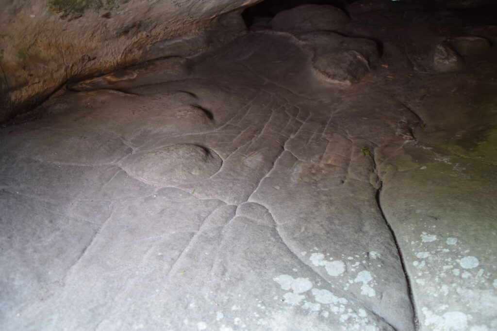
Recent research at the site has identified a miniature hydrographic network, engraved on the shelter floor to a metric scale. This network schematically represents natural flows, from uplands to streams and rivers, leading to areas depicting downstream lakes and swamps. The whole is integrated with natural ground morphologies, combining sculpted and carved elements in sandstone.
Two main components stand out. The first, a “terrace”, features depressions in which water could accumulate before being channelled, via an engineered drain, to a second area located in the lower part of the shelter. This lower zone is marked by natural bulges in the sandstone, between which a network of grooves has been etched, leading the water to a larger depression. These flows may have occurred naturally after a rainfall, or may have been triggered by a voluntary inflow of water.
A comparison of the relief and flow patterns engraved on the site with the geomorphological features of the École valley, where the shelter is located, reveals a striking correspondence. The terrace corresponds to the sandstone plains, dotted with pools and wetlands, that dominate the valley. The engraved drainage network is reminiscent of rambling valleys and swamps as they existed before human development, while the depressions in the lower part evoke the marshes and stretches of open water that once punctuated the valley.
This discovery does not constitute a “map” in the modern sense, with its precise distances, directions and indications. Rather, it’s a miniature, three-dimensional representation of how a landscape worked. For Palaeolithic peoples, the direction of watercourses and the functional characteristics of the terrain were of prime importance, far more so than our contemporary concepts of distance or time.
Multiple meanings to this “cartography
Upper Paleolithic communities probably didn’t need this map to find their way around a landscape they could observe directly from the hilltop. So why such a layout? This miniature three-dimensional representation could have fulfilled several functions: a tool for planning hunts by visualizing animal movements according to the terrain, a territorial marker to signify areas of strategic or symbolic importance, or a medium for transmitting knowledge between group members or generations.
Combining sophisticated hydraulic devices with artistic staging that combines sexual figuration with miniature representations of the landscape, these installations demonstrate a complex understanding of the environment and a capacity to intervene in it in a meaningful way. By integrating these elements in the same shelter, the inhabitants of this period were perhaps expressing profound ideas about their relationship with nature and life, combining utilitarian practices, symbolism and culture.
However, the exact meanings of these creations remain enigmatic. They reflect a Paleolithic worldview that largely eludes us, since it is based on concepts and cultural values that are no longer directly accessible, and which are nourished by our own imaginations and worldviews. This discovery opens a window onto the cognitive and artistic capacities of our ancestors, while at the same time leaving an element of mystery that fuels our curiosity about their conception of life and nature.

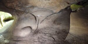
Inside the cave, with a view of the drainage channels that have been laid out. Photo courtesy of Pascal Crapet.
A window on the cognitive evolution of human societies
This three-dimensional map testifies to an in-depth knowledge of natural dynamics and advanced technical know-how. It illustrates a global intelligence where creativity, observation and technical mastery come together. More than a simple utilitarian or artistic object, this miniature from the shelter reveals the ability of prehistoric societies to mentally conceptualize complex landscapes and extract the essential elements to represent them in tangible form.
The discovery of these two installations marks a major cognitive advance. This research has shown that Paleolithic inhabitants modified sandstone to direct and infiltrate rainwater, an innovation never before identified by archaeologists. These interventions demonstrate sophisticated engineering combined with a deep understanding of the natural properties of rocks and water.
In addition to the mythological aspect of water, supposedly the source of all life, the use of water in these installations adds an interactive dimension to this unique object. In these two installations, prehistoric humans have taken advantage of the rock’s natural features, limiting their interventions on it, reminiscent of the techniques used in painted caves, where the rock’s natural reliefs were enhanced by paintings. But to this “economy” of intervention is added a dimension of respect for the natural space, applying here to the rocks that it was also necessary to respect as much as possible. These prehistoric societies didn’t just survive in their environment: they interpreted it, transformed it and gave it meaning.
A wealth of cooperative studies
This discovery highlights the crucial importance of interdisciplinary collaboration, particularly between geology and archaeology. These fields, though distinct, complement each other to offer an enriched vision of the interactions between human societies and their environment through time.
Dr. Anthony Milnes underscores this synergy when he says: “We believe that the most productive research takes place at the frontiers between disciplines.” Médard Thiry, for his part, stresses the importance of field studies: “It is essential to re-evaluate observations in the field and to make frequent visits to the sites studied. Our project has clearly shown that ideas and interpretations are not born instantaneously, but emerge through new observations and interdisciplinary discussions. These exchanges, fostered by the Mines Paris – PSL approach, enable us to push back the boundaries of our knowledge.”
This collaboration illustrates how dialogue between scientific disciplines can open up unprecedented perspectives, transforming isolated discoveries into genuine advances for our understanding of human history and the Earth.
Find out more :
- Thiry, M., and Milnes, A. (2024), “Palaeolithic map engraved for staging water flows in a Paris basin shelter”. Oxford Journal of Archaeology, doi.org/10.1111/ojoa.12316
- University of Adelaide press release: Read