On World Soil Day, held on Friday, December 5, 2025, the Center for Geosciences and theHigher Institute of Engineering and Environmental Management (ISIGE) at Mines Paris – PSL highlighted their research on erosion, sediment transport, vegetation cover, and soil protection, conducted by a multidisciplinary team: Jean-Louis Grimaud, Olivier Stab, Christine Franke, Bruno Tessier, Sophie Guillon, professors and researchers at the Center for Geosciences, and Emmanuel Garbolino, assistant professor at ISIGE.
Observing, understanding, and quantifying water erosion
A rapidly accelerating phenomenon
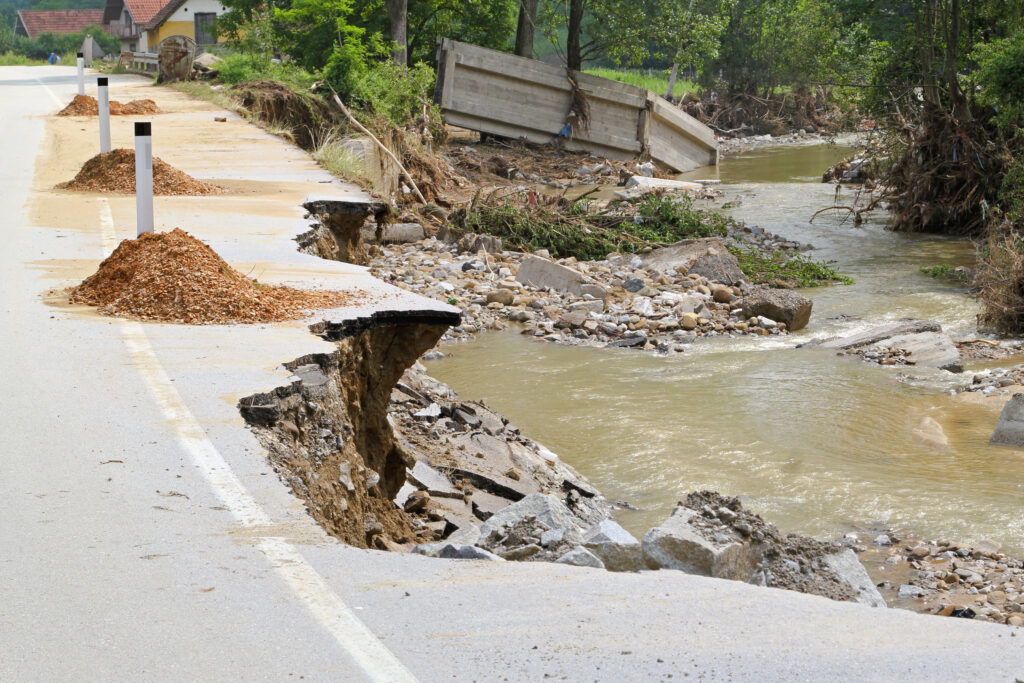
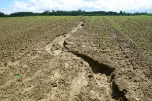
Water erosion, i.e., soil loss due to the action of rain and runoff, is currently the most worrying form of erosion in Europe. It threatens agricultural land, mountain areas, vineyards, and Mediterranean regions subject to more intense and irregular rainfall.
Researchers at the Geosciences Center are analyzing this phenomenon on different temporal (from extreme events to millennia) and spatial (from large watersheds to areas of a few square meters) scales.
Their goal is to quantify erosion rates and model the processes to better understand how they would evolve in a warmer and more contrasting climate.
Complementary scales of analysis:
- At the watershed scale: Erosion in the Canche basin (Nord-Pas-de-Calais) is the subject of a collaboration with the University of Lille, IMT Nord Europe, and IFP Energies nouvelles (IFPEN). Sediment flows are measured and then integrated into numerical models such as TOPMODEL, LisFlood, and CEASAR, notably in the thesis of Marylin Uchasara, a doctoral student at the Center for Geosciences. The Voire basin (Aube) has been studied over the very long term for a storage project by the National Agency for Radioactive Waste Management (ANDRA). Gully formation, regressive erosion, and diffuse erosion have been investigated using statistical (RUSLE) and physical (LEM) models.
- At the landscape or slope scale: physical processes are studied in greater detail: infiltration, runoff, particle detachment by raindrop impact, formation of gullies, micro-tunnels, etc., depending on the intrinsic and extrinsic characteristics (moisture, surface roughness, crusting, vegetation cover, etc.) of the soil.
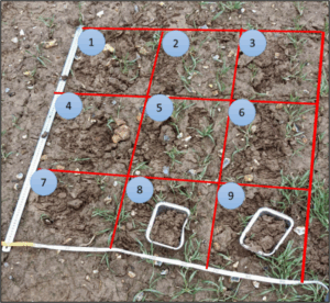
Erosion also depends on the extrinsic characteristics of the soil: vegetation cover, roughness, the presence of a crust, water saturation, etc., which require frequent sampling measurements and field observations (Delaporte 2024).
Soil erosion and climate change
A major risk for Europe
Climate projections predict an increase in the intensity of extreme precipitation, particularly in northern France and the Paris Basin, which could adopt a Mediterranean climate by the end of the century according to the most pessimistic scenarios. Extreme events, such as those that affected Germany in 2021 in the Aare river basin and France in 2024 in the Valence region, illustrate the potential violence of so-called hundred-year or thousand-year rains.
But beyond these disasters, silent and continuous erosion carries away around 1 billion tons of soil every year, according to estimates by the European Commission. In addition to soil loss, erosion has indirect effects such as water quality degradation, increased risk of flooding and mudslides, and sedimentation of waterway infrastructure. These issues are at the heart of the TRACS project, in partnership with VNF (Voies Navigables de France) and the Artois-Picardie Water Agency. TRACS tracks agricultural and urban sediments, hydro-sediment transport, and sediment recovery, in collaboration with several industrial partners, including EDF. Erosion also contributes to a reduction in soil carbon stocks, thereby exacerbating climate change. In light of these challenges, combating soil erosion is a priority for the sustainability of agricultural systems and the preservation of European ecosystems.
Researchers at Mines Paris – PSL are therefore examining a crucial issue: are historical data still relevant for predicting soil erosion in a rapidly changing climate?
Modeling soil loss: decision-making tools
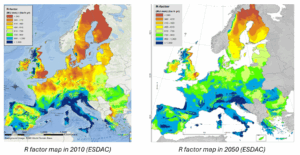
To inform public policy, the European Soil Data Center (ESDAC) uses models such as RUSLE (Revised Universal Soil Loss Equation) to, among other things, create rainfall erosivity maps for today and the coming decades. These maps already indicate a significant increase in the R factor, i.e., the potential energy of rainfall that can cause erosion. To address these risks, agricultural practices can be improved to better conserve soil.
According to the scientific community, the average rainfall erosivity factor (R in the RUSLE model) will increase dramatically in the coming decades.
Challenges for waste management
Protecting soil cover
Beyond agricultural issues, erosion also threatens waste storage covers (particularly for radioactive waste), which are designed to last several hundred to several thousand years. Under the effect of more intense extreme rainfall, these covers can deteriorate, compromising their protective role.
The Geosciences Center has been conducting studies on this subject for many years for the National Agency for Radioactive Waste Management (ANDRA). These studies are based on complementary approaches using:
- (statistical) models based on measurements (weather data, soil samples, etc.) such as RUSLE,
- numerical simulations of diffuse or channeled erosion processes (using Landscape Evolution Models),
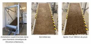
- analog models: smaller-scale experiments in climate chambers.
The experimental facility makes it possible to reproduce extreme rainfall (up to 100 mm/h), vary soil moisture (and thus simulate the impact of droughts), and observe erosion processes in real time. This project is part of a collaboration with ANDRA’s Centre de Stockage de la Manche (CSM) and the Ecotron de Nemours (ENS) and offers many prospects within the framework of the European Partnership on Radioactive Waste Management (EURAD2), within the CLIMATE and SUDOKU work packages.
A key role for vegetation cover
Vegetation is an essential lever in the fight against erosion.
The ISIGE is conducting a study on the influence of vegetation cover on soil stabilization:
- reduction of the kinetic energy of raindrops,
- limitation of runoff,
- improvement of infiltration,
- fixation of fine particles.
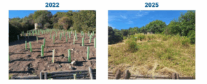
In 2022, an ecological restoration project (in collaboration with the company ASES and the Life Terra Foundation) was launched in an urban park in Nice, selecting plant species from nearby areas with a drier climate, such as certain regions of Spain. The resilience of these species to local climate change was tested digitally using ecological forecasting models developed at ISIGE. The aim was to ensure their survival in the face of future droughts while guaranteeing the expected ecosystem services. The result: a success rate of over 80% for the 4,000 plants tested, a promising rate that confirms the value of this approach.
This knowledge is crucial for guiding agricultural practices and restoring the most vulnerable soils.
Complex physics, multiple challenges
Erosion results from a series of physical processes occurring at different scales:
- micro: impact of raindrops (“splash effect”),
- meso: sheet runoff, gully formation,
- macro: rill erosion, sediment transport to and into rivers.
Researchers at the Geosciences Center are working to unravel this complexity in order to provide concrete solutions to societal challenges: food security, waste management, risk assessment, and adaptation of territories to climate change.
To go further
- ESDAC (European Soil Data Center)
- Soto Vargas H.V., A. Evette, S. Guillon, P. Fleckinger, and E. Garbolino (2025). Defining Resilient Nature-based Solutions for riverbank stabilization using species distribution models with 2050 climate projections. 6th International Conference on Soil Bio- and Eco-Engineering SBEE2025- The Use of Vegetation to Improve Slope Stability. Mexico.
- Matthews, Francis, Gert Verstraeten, Pasquale Borrelli, et al. 2023. “EUSEDcollab: A Network of Data from European Catchments to Monitor Net Soil Erosion by Water.” Scientific Data 10 (1): 515.
- Patault, E., Alary, C., Franke, C., Abriak, N.-E., 2019. Quantification of sub-basin contributions using a confluence-based sediment fingerprinting approach on the Canche river catchment (France), Science of the Total Environment, 668, 457–469,
- Portzer, Gabriel, Jean-Louis Grimaud, Albert Marchiol, et al. 2024. Experimental simulation of soil erosion in the context of climate change in NW France. November 27. https://doi.org/10.5194/egusphere-egu24-11138.
- Delaporte, Morgan. 2024. “Study of erosion issues in the Hauts-de-France region: understanding the dynamics of hydrosedimentary flows and their role in watercourse quality.” Earth and Universe Sciences/Hydrology, Ecole nationale supérieure Mines-Télécom Lille Douai.