
Geology field course: interpreting landscapes to understandtoday’s challenges

What can a landscape reveal to those who know how to observe it? A cliff, a river bend, a few grains of sand, or a layer of limestone preserve traces of vanished seas, ancient climates, and upheavals dating back millions of years. But they also allow us to address very current issues: Where can we find and store resources? How does water flow in rivers and the environment? What effects do our developments have on natural habitats? From September 20 to 26, 2026, first-year students at Mines Paris – PSL left the classrooms for their “geology field trip.” Spread across six field sites—from the Paris Basin to the Pyrenees, via the Morvan, Normandy, and the Alps—they learned, in a wide variety of landscapes, to observe the Earth as a dynamic system and to appreciate how much understanding it can offer engineers.
A first scientific field experience
It all begins with an exercise that seems simple: observation. A rock, its color, the size of its grains, a fossil, the dip of a stratum, or the shape of a valley—all of these are clues. Pieced together, they allow geologists to reconstruct an environment that may have ceased to exist millions of years ago.
Sandstone, for example, can indicate the presence of an ancient river or coastline, while other sedimentary rocks reveal the existence of seas that no longer exist and of changing climates. Fossils, for their part, provide valuable clues about the living organisms and environmental conditions of a particular era. All of these elements, when considered together, allow us to trace back in time and reconstruct the geological history of a region.
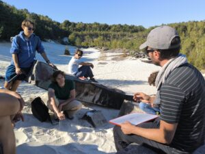
This is the approach students experience during their field geology course. With notebooks in hand, they observe rocks at outcrops, make sketches, and seek to understand the geological structures around them. In the Paris Basin, they move from studying Montmartre to the rocks of the Morvan, before exploring the Yonne Valley, the Bassée alluvial plain, and the sands of Fontainebleau. At each stage, their observations either reinforce or challenge their initial hypotheses, enabling them to reconstruct the history of these environments (environment, landscape, climate, etc.).The goal, therefore, is not simply to learn how to identify rocks, but to develop a genuine scientific and naturalistic approach directly linked to climate change, by distinguishing observed facts from their interpretation and learning to draw conclusions from sometimes incomplete evidence, without losing sight of the uncertainties that accompany them.
Rocks: archives of past climates
Rocks also serve as valuable climate archives. The presence of certain fossils or minerals allows us to reconstruct the temperature and humidity conditions that prevailed in the past, while the study of sediments deposited by ancient rivers provides insight into changes in their flow rates and erosion during periods of warming. Landscape interpretation—or geomorphology—also sheds light on these climate variations, as evidenced by valleys in the Alps and Pyrenees that were once occupied by large glaciers. Certain marine organisms even preserve, in the composition of their shells formed over the course of the seasons, clues that allow geologists to reconstruct seasonal temperature variations, beyond mere climate averages.
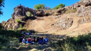
The Pyrenees field course focuses on observations that help contextualize climate changes over the long term and understand the influence of phenomena as diverse as continental drift, the alternation of glacial and interglacial periods, volcanism, and variations in solar activity. All these processes operate on very different time scales and illustrate the interplay between geological processes, the regulation of the CO2 cycle, and global climate. Studying these past changes thus helps us better understand current transformations, while taking into account the differences between ancient natural mechanisms and contemporary global warming.
Along the Normandy trail, this long-term perspective is particularly evident at the Vaches Noires cliffs in Villers-sur-Mer. After exploring the paleontological collections at the Paléospace, students observe firsthand the fossil-rich rock formations and coastal claystones. These are all remnants of vanished environments that help reconstruct part of the region’s geological and climatic history.
When a Rock Becomes a Resource
Understanding how a rock formed doesn’t just provide insight into the past. It also helps determine its properties: Is it porous? Fractured? Impermeable? How can water or gas flow through it? Are there any mineral deposits? How far does it extend underground?
These properties play a vital role in numerous industrial and energy applications. Depending on their composition and structure, rocks can contain mineral resources, host underground reservoirs, or allow fluids to flow through them—a phenomenon exploited in certain geothermal projects. Understanding their formation and structure is therefore essential for identifying subsurface resources and planning their exploitation.
During field trips to various sites, students discover how geological formations can constitute resources and how these have been exploited over time. In Pierre-Perthuis, in the Morvan region, they focus on fluorite mineralization, while in Digne-les-Bains and La Mure, the study of geological formations provides an opportunity to explore the topic of coal; and in the Pyrenees, observing a discordance offers a perfect opportunity to discuss the numerous metal deposits (uranium, nickel, etc.) in this type of setting. These observations thus provide a better understanding of how a region’s geological history determines the resources it contains and influences the human activities that develop there.
In Normandy, this link between scientific observation and industrial application takes the form of a study of underground reservoirs. After studying the sandstones at Darvault, the students visit the Beynes gas storage site, where they analyze the geological characteristics of the reservoir and the systems used to inject and extract gas from it. A few days later, they explore a former underground chalk quarry in Caumont, which allows them to observe from the inside the rock’s structure, water flow, and the dissolution processes that create cavities, as well as the associated risks of collapse.
From a grain of sand to an underground reservoir, the students learn to connect their field observations to the functioning of much larger geological structures. They also put this knowledge into practice by calculating the volume of gas a reservoir could store and by modeling river dynamics, to better understand how natural phenomena can be studied and quantified for practical applications.
The subsurface: a space to explore… and to share
Because the subsurface is not an empty space: we extract water and raw materials from it, we can store gas there, and we are considering using it to sequester CO₂ or contain certain types of waste. Each of these uses requires a detailed understanding of geology, fluid flow, and chemical interactions—sometimes over very long time scales.
In the field, these issues take on a concrete dimension. The Normandy field trip, for example, takes students to a hazardous waste storage site in Tourville-la-Rivière. In the Paris Basin and the Morvan region, the study of resources is situated within a landscape largely shaped by the needs of the Paris metropolitan area: water, aggregates, energy, and materials have helped transform local landscapes and land uses.
In the Pyrenees, students learn to understand the structure of geological reservoirs, from observing rocks in the field to digitally modeling them, using software developed by the Mines Paris – PSL Geosciences Center. These methods explore the potential for uranium and natural hydrogen extraction, as well as underground CO₂ storage. The Laragne site in the Alps sheds light on these issues through the study of salt deposits dating back approximately 250 million years. Observing these deposits allows students to explore the geological mechanisms at work in the salars of South America—vast salt flats, some of which contain brines rich in lithium, a resource essential for battery manufacturing.
Geology thus raises questions that go far beyond the mere characterization of rocks: Which resources should be exploited, how, and with what uncertainties and impacts?
An important aspect of learning is precisely becoming aware of the limits of our knowledge. The subsurface can never be fully observed: geologists rely on outcrops, boreholes, measurements, or models to reconstruct what remains largely inaccessible. Students thus encounter problems for which the data are incomplete and where there is not necessarily a single solution.
Understanding the effects of our development projects
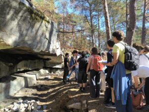
A geologist’s perspective extends beyond the subsurface. It also helps us understand how landscapes are shaped and evolve over time, particularly through the action of water. Rivers are a good example: by transporting sediment, eroding their banks, or overflowing their banks, they continually transform their environment. But this natural balance can be disrupted by human activities. Construction, material extraction, agriculture, and urbanization alter the flow of water and sediments, sometimes with significant consequences for erosion, flooding, ecosystems, and agricultural activities themselves.
In the Alps, the La Mure site provides an opportunity to explore the issue of dams, from studying the geological conditions necessary for their construction to their impacts on the environment and the functioning of waterways. In Digne-les-Bains, students take a broader look at land-use planning in mountainous areas and the natural hazards to which these regions are exposed.
In the Bassée Plain, they study the evolution of the Seine, and in Normandy, observing the meanders downstream from Rouen, the alluvial terraces, and the former Austreberthe Valley helps them understand how a river system evolves over time.
These mechanisms are also linked to current climate challenges. More concentrated precipitation during intense events can increase erosion and runoff, while soil sealing limits water infiltration. Combined with the pressure on aquifers, these phenomena directly raise questions about the future availability of groundwater resources.
Training engineers to tackle complex systems
Beyond the hammers, compasses, hiking boots, and field notebooks, the geology field course provides hands-on learning directly tied to engineering education.
Over the course of a week, students learn to shift their perspective—moving from observing a rock to understanding a landscape—while sometimes tracing Earth’s history back several hundred million years. To do this, they draw on various scientific methods, from mapping to modeling, to understand how geological phenomena influence our environment and human activities.
Above all, fieldwork confronts them with the complexity of natural systems, where phenomena are numerous and our knowledge is often incomplete. Studying a rock can thus shed light on climate history while providing information about underground resources, whereas studying a river helps us understand how natural processes interact with human developments.
This is undoubtedly one of the main lessons of this week: learning to observe before drawing conclusions, to test models against reality, and to deal with uncertainty. It’s a way, right from the first year, to discover that to understand contemporary issues, we sometimes need to start by looking at what lies beneath our feet.
Video testimonial: from the field to the major challenges of the future
The engineering students’ geology field Course
In this video, Jean-Louis Grimaud, a faculty member and researcher at the Mines Paris–PSL Geosciences Center, along with Marguerite Gounot and Ethan Cantor, first-year civil engineering students, reflect on this educational experience and what it has taught them:
