Understanding water to protect it better: the work of the Geosciences Centre
Published on 22 March 2026
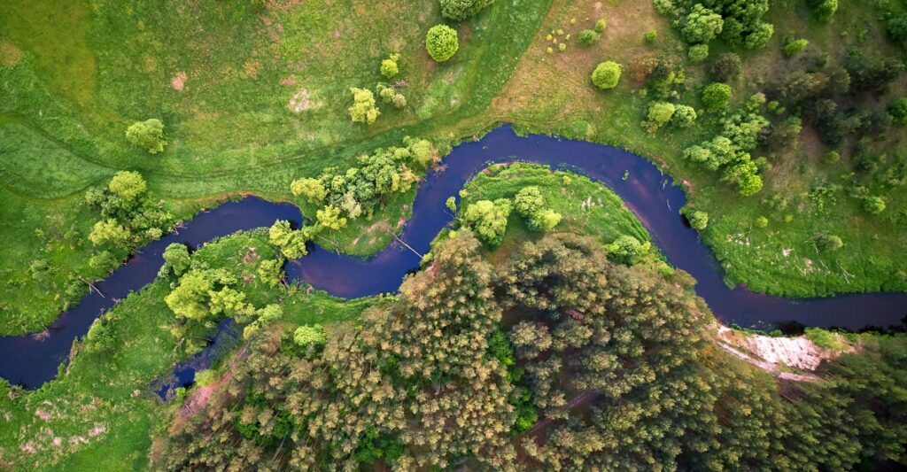

When we talk about water resources, we naturally think of rivers, lakes or groundwater. But these systems never operate in isolation. Water circulates constantly between the surface, the subsurface, the atmosphere and living ecosystems, carrying with it matter, energy and chemical elements.
It is precisely this integrated view of water that Nicolas Flipo focuses on. A hydrologist and hydrogeologist by training, he studies the fate of water resources across different regions, the exchanges between surface water and groundwater, the biogeochemical processes taking place within them, and their response to climatic and anthropogenic drivers. The aim: to provide robust scientific tools to inform public policy decisions and support the transition towards more sustainable water management.
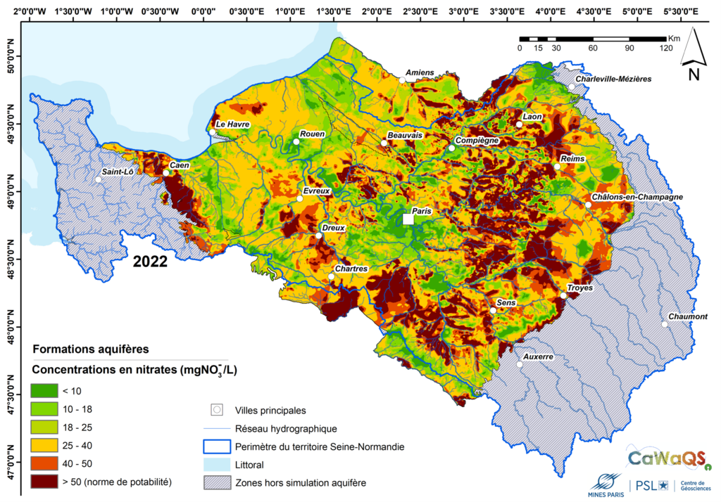
Simulation of nitrate concentrations (mg/L) in the groundwater of the Seine-Normandy basin. Produced using the CaWaQS modelling tool, developed at the Centre for Geosciences, this map shows nitrate concentrations in the region’s main aquifers, in the areas most vulnerable to surface pollution. The values shown correspond to a simulation at the end of 2022 and illustrate the spatial distribution of this type of major contamination. Map by Nicolas Gallois.
One of the key issues addressed recently is the impact of long-term climate variability on groundwater levels. A recent study, conducted in collaboration with M2C – Continental and Coastal Morphodynamics – UMR 61430, CNRS – University of Rouen Normandy, shows that interannual and decadal climate fluctuations can cause variations of several metres in groundwater levels in the Seine basin.
These findings are crucial: they reveal that subtle changes in rainfall variability can increase the frequency and severity of groundwater droughts or, conversely, groundwater-related flooding. A better understanding of these mechanisms enables us to anticipate future risks and adapt the management of drinking water, agriculture and infrastructure.
In situ sensors now enable high-frequency measurements of water quality, particularly of dissolved oxygen in rivers. Whilst this data is invaluable, conventional models often assume constant biological parameters, even though the activity of microorganisms varies over time.
To address this limitation, as part of multidisciplinary research conducted at the Centre for Geosciences, in collaboration notably with Thomas Romary and PhD students Shuaitao Wang and Masihullah Hasanyar, the ProSe-PA software was developed. This unique tool uses methods to assimilate dissolved oxygen measurements with the RIVE biogeochemical model to estimate changes in the physiological properties of microbial communities present in river waters, such as phytoplankton and bacteria.
This approach significantly improves the simulation of dissolved oxygen, particularly during algal blooms, with parameters consistent with the scientific literature. However, there is still scope for improvement in better integrating the latest-generation sensors to enable more precise monitoring of organic matter fluxes, which are one of the drivers of microbial activity and strongly influence oxygen concentrations during low-flow periods.
Beyond fundamental research, Nicolas Flipo is involved in innovative observation systems, such as the MOLONARI ecosystem, which measures water and energy exchanges between rivers and their beds in situ. He has also contributed to the international SWOT satellite mission (NASA/CNES), designed to observe surface waters on a global scale.
This integration of observations, modelling and dialogue with public stakeholders illustrates the commitment of Mines Paris – PSL: to produce rigorous, open and useful science, capable of informing collective decisions in the face of water-related challenges.
In an era of climate change and the increasing scarcity of certain resources, Nicolas Flipo’s work highlights a scientific and societal truth: we can only properly protect what we understand. By revealing the hidden dynamics of hydrosystems, Mines Paris – PSL is actively helping to build a more resilient water management system, one that is equal to the challenges of the 21st century.
Lisa Baulon, Manuel Fossa, Nicolas Massei, Nicolas Flipo, Nicolas Gallois, et al.. Sensitivity of groundwater levels to low-frequency climate variability in a large watershed. Science of the Total Environment, 2024, 957, pp.177636. ⟨10.1016/j.scitotenv.2024.177636⟩. ⟨hal-04807953⟩
Shuaitao Wang, Nicolas Flipo, Josette Garnier, Thomas Romary. Bayesian inversion of bacterial physiology and dissolved organic carbon biodegradability on water incubation data. Science of the Total Environment, 2024, 955, pp.177252. ⟨10.1016/j.scitotenv.2024.177252⟩. ⟨hal-04765188⟩
Shuaitao Wang, Vincent Thieu, Gilles Billen, Josette Garnier, Marie Silvestre, et al.. The community-centered freshwater biogeochemistry model unified RIVE v1.0: a unified version for water column. Geoscientific Model Development, 2024, 17 (1), pp.449-476. ⟨10.5194/gmd-17-449-2024⟩. ⟨hal-04456280⟩
Shuaitao Wang, Nicolas Flipo, Thomas Romary, Masihullah Hasanyar. Particle filter for high frequency oxygen data assimilation in river systems. Environmental Modelling and Software, 2022, 151, pp.105382. ⟨10.1016/j.envsoft.2022.105382⟩. ⟨hal-03635705⟩
Map: Gallois, N. (2024). Modélisation des pollutions diffuses d’origine agricole sur le territoire Seine-Normandie – Actualisation des modélisations de l’état de pollution nitrique des masses d’eau souterraine en prévision de l’état des lieux 2025 de l’Agence de l’Eau Seine-Normandie. Rapport technique d’étude R11012024NGAL, ARMINES/Mines Paris, PSL Université, Centre de Géosciences, 146 p.
Git repository for open-source software: