Observation, Impacts, Energy Centre (OIE)
Observing Energy to Illuminate the Transition
Affiliated with Mines Paris – PSL, the Observation, Impacts, Energy Centre (OIE) conducts research at the intersection of Earth observation, energy systems and environmental impact modelling. The research presented here lies squarely within the field of energy resource observation, with a particular emphasis on solar energy.
OIE’s research pursues a clear objective: to better measure, model, understand and forecast solar resources, in order to facilitate the small and large-scale integration of photovoltaics into electricity systems. AI is not used as a black box, but as a tool that complements and enhances physical models.
Observing the Sun
A Matter of Scales and Data
Measuring solar radiation relies on multiple data sources, each involving trade-offs between spatial and temporal resolution:
- Ground-based sensors (pyranometers, hemispherical sky cameras): highly accurate at local scale, with fine temporal resolution
- Satellite data: wide spatial coverage with kilometer-scale resolution, and temporal resolution of a few minutes
- Numerical weather models: regional to continental perspectives, but with coarser time steps
These datasets are highly heterogeneous in both format and scale. One of the major research challenges therefore lies not only in physical analysis, but also in accessing, aligning and extracting value from massive and diverse datasets.
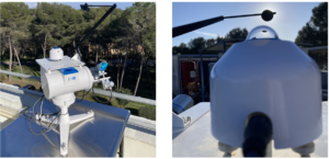
Solar monitoring station installed on the rooftop of Building I on the campus of Mines Paris – PSL in Sophia Antipolis, used to measure and analyse surface solar irradiance in support of photovoltaic assessment and forecasting and energy system optimisation.
Automating Science
AI That Frees Up Research Time
At OIE, AI is first and foremost used to accelerate and secure scientific workflows. Intelligent agents now enable researchers to query complex databases such as the Copernicus Atmosphere Monitoring Service (CAMS), ERA5, Copernicus regional reanalysis for Europe (CERRA) and Météo-France, using natural language commands. These tools automatically generate data processing and visualisation pipelines.
The impact is tangible: research time can be refocused on physical analysis and the understanding of underlying phenomena, rather than on the tedious handling of data.
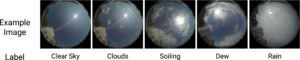
€300 Cameras to Forecast the Sun
One of the most emblematic innovations developed at OIE, within the framework of the SciDoSol sponsorship chair, is a low-cost hemispherical sky camera. It is built from accessible components such as Raspberry Pi microcomputers and wide-angle cameras, at a cost of around €300.
Pointed towards the sky, the camera captures images of cloud cover. Using pre-trained convolutional neural networks (CNNs) adapted to sky imagery, it enables:
- Classification of sky conditions (clear, cloudy, rain)
- Detection of maintenance issues (soiling, condensation)
Knowledge of the states of the camera and sky pave the way for accurate modelling of surface solar irradiance incident on tilted planes of photovoltaic modules. These developments deliver tangible results, also providing very short-term solar forecasts that are essential for grid operators facing the integration of the rapid variability of solar power generation.
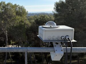
The prototype of the low-cost fish-eye camera installed on the rooftop of Building I on the campus of Mines Paris – PSL in Sophia Antipolis.
Simulating Clouds to Better Understand Them
In large photovoltaic plants, solar radiation is never uniform: a single cloud can cast part of a site into shadow within seconds. To anticipate such variations, OIE researchers combine physical modelling and deep learning.
Atmospheric simulations are used to generate synthetic multi-view sky images, data which is rarely available. From these images, neural networks learn to predict surface solar irradiance at fine spatial scales for photovoltaic plants. This work provides insights on how many imagers to install within the plant, and where to position them for best value.
The scientific challenge is clear: ensuring that AI remains firmly anchored in physical reality, rather than relying solely on visual or statistical performance. Therefore, these approaches are confronted with real networks of sky cameras, particularly in Germany, in order to assess the physical realism of the generated images.
Next-Generation Satellites
AI Facing Real-World Complexity
The arrival of third-generation meteorological satellites marks a turning point: finer spatial resolution, more frequent imagery—but also new scientific challenges. At these scales, classical assumptions of physical models, notably pixel independence, no longer hold due to parallax effects and the three-dimensional structure of clouds.
Research at OIE shows that convolutional neural networks, capable of jointly processing spatial and spectral information, provide more accurate estimates of surface solar radiation than traditional physical models.
The result: more reliable resource assessment for energy systems, agriculture and energy meteorology.
Making Invisible Photovoltaics Visible
Another major breakthrough is the DeepPVMapper project, which combines AI and aerial imagery to map rooftop photovoltaic installations across France. By detecting nearly 500,000 systems, this method reveals a reality that is largely underestimated by official registries.
The findings are striking:
- Around 10% of rooftop photovoltaic capacity missing at the national level
- Up to 48% locally in certain regions
The direct consequence is a much more accurate picture of the photovoltaic fleet, which is essential for grid stability and energy planning.
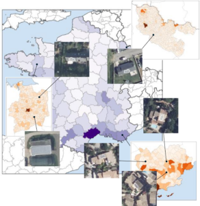
DeepPVMapper: mapping rooftop photovoltaic systems using aerial orthophotography.
Frugal, Explainable and Responsible AI
At OIE, performance does not come at the expense of sobriety. Recent research explores computationally efficient AI models capable of predicting the balance of the energy mix (solar, wind, imports, thermal generation) based on historical data. The aim is to provide short-term and day-ahead forecasts of the energy mix using low-cost computations for fast processing and retraining. This information is particularly of value for operational energy and storage management systems.
Observing, Understanding, Anticipating
AI in the Service of Energy
These research activities were presented during the AI Workshop at Mines Paris – PSL, a key event designed to showcase AI research, foster exchanges between researchers, PhD students and faculty members, and encourage new collaborations. At OIE, the workshop reflects a collective momentum: making AI a structuring tool for energy research, in service of the ecological transition.
By combining Earth observation, physical models and AI, research at OIE demonstrates that AI can be far more than a predictive tool: it can become a means of understanding the physical world, making invisible phenomena visible and providing concrete support for the energy transition.
Further reading
Bauer, V., Eissa, Y., Saint-Drenan, Y.-M., Blanc, P., 2025. Measuring diffuse sky radiance with an affordable and open-source all-sky imager. Young Scientist Symposium 2025, 18 Nov 2025, Klosterneuburg, Austria.
Becquet, V., Blanc, P., Saint-Drenan, Y.-M., Eissa, Y., 2025. Deep learning and spatial context for global horizontal irradiance estimation: Addressing independent pixel approximation limitations with satellite imagery. EMS Annual Meeting 2025, 7–12 Sep 2025, Ljubljana, Slovenia.
Kasmi, G., Saint-Drenan, Y.-M., Trebosc, D., Jolivet, R., Leloux, J., Sarr, B., Dubus, L., 2023. A crowdsourced dataset of aerial images with annotated solar photovoltaic arrays and installation metadata. Scientific Data, 10, 59.
Kasmi, G., Touron, A., Blanc, P., Saint-Drenan, Y.-M., Fortin, M., Dubus, L., 2024. Remote-sensing-based estimation of rooftop photovoltaic power production using physical conversion models and weather data. Energies, 17(17), 4353.
Magliaro, E., Voyant, C., Jheelan, Y., Michiorri, A., Julien, A., Eissa, Y., Bright. J., 2025. Energy-consistent multi-input multi-output multi-horizon extreme learning machines with embedded reconciliation for multi-source power forecasting.
Meddahi, A., Tuomiranta, A., Guillon, S., 2025. Skill‐driven data sampling and deep learning framework for minute‐scale solar forecasting with sky images. Solar RRL, 9 (4), 2400664.
Verbois, H., Saint-Drenan, Y.-M., Becquet, V., Gschwind, B., Blanc, P., 2023. Retrieval of surface solar irradiance from satellite imagery using machine learning: pitfalls and perspectives. Atmospheric Measurement Techniques, 16, 4165–4181.
Voyant, C., Despotovic, M., Notton, G., Saint-Drenan, Y.-M., Asloune, M., Garcia-Gutierrez, L., 2025. On the importance of clearsky model in short-term solar radiation forecasting. Solar Energy, 294, 113490.